As the winter progressed and I reviewed my coordinates collected so far I began to sort out waterfalls. There were some, like Queen Anne's and Douglass Houghton Falls, that were nestled deep in the woods and could use some help from a GPS mark. There were many others, like Eagle River and Tobacco Falls, that did not. These falls were near roads, visible from satellite imagery (like Google Maps), and were just plain easy to find.
Near the top of my list of spots to hunt down and tag were two on Gratiot River up by Ahmeek. These two waterfalls (Gratiot River and Conglomerate) were fairly remote for the Keweenaw, off the beaten track and difficult to find if you weren't familiar with the area. The only way to reach the downstream one was a tough four mile drive down a muddy logging track also known as Bumbletown Road. A four mile drive that would be buried deep in snow. So I decided to try for another approach, one that would take me through a thick forest and swamp.

Eastern entrance to preserve
My goal was simple - I would start on Tanskanen Road, walk a mile west to Gratiot River Falls, then follow the river upstream for a mile to Conglomerate. Without snowshoes. In Feburary. I pulled up to the dead end of Tanskanen and was surprised to see a large sign surrounded by tracks. Apparently this was part of a conservancy. Maybe this hike wouldn't be too tough.
Logan and I piled out of my car and passed the sign to find a wide trail packed down by snowshoes and skies. It was so packed that my simple boots didn't even break through. I try to avoid such paths, not wanting to break through and ruin a track for future skiers, but today the hard surface and cold temps made sure my passage wouldn't do any lasting harm.

A wide and easy route
Our easy path lasted for around twenty minutes before starting to curve north. I didn't want to go north. The path may go to Lake Superior, or dead end, or even circle back up to Farmer's Block - it didn't look like it was going to go to Gratiot River Falls. Logan and I sadly cut off the trail, trying our best to follow animal tracks west. For the most part I sunk down to my thighs and trudged a deep path and Logan bounced behind me.
We didn't make bad time. There was plenty of daylight today and I had an abundance of energy after being so cooped up this winter. Soon we stood upon a small ridge overlooking a barren dip below. This was the river valley, hundred feet or so at most, and somewhere down there was our waterfall. I leaned in tackled the deeper snow in a flurry of white.

Across the wide gorge
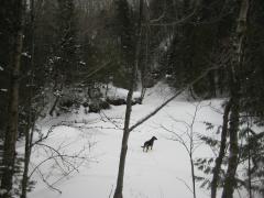
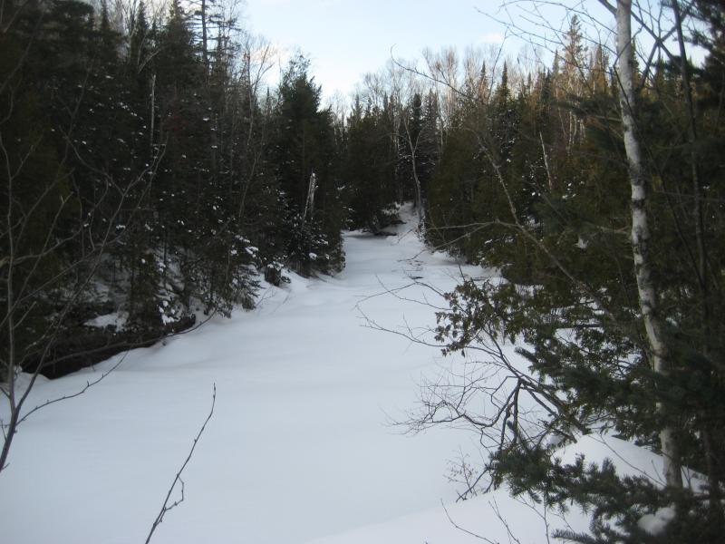
There wasn't far to go. Maybe fifteen minutes from the top of the ridge and we stood at the river's edge. It was cluttered with brush, overhanging the banks and obscuring the view to either side. I didn't dare travel out onto the flat white banks, remembering how deep the pools of water were here in the summer. A few mounds of white showed up to the left and some open water gurgled to the right. This was our waterfall, all right. I marked the location on my GPS and turned upstream.

Thick brush along the river
For the last half hour I had been fighting my way through tag alder. They group and cluster down here in this river valley, overlapping each other and creating countless obstacles to jump over and dip under. They are probably worse to go through in the summer, when leaves obscure the trunks and mosquitoes are circling like miniature vultures, but they were still tiring today.
To make things worse I began to break through in a few locations. As I moved upstream, deeper into the swamp between the two waterfalls, an occasional stray footstep would break through the snow and sink into an icy puddle. This, this was no fun. I decided to cut back east, back to the ridge, and follow that to Conglomerate Falls.

Horribly thick swamp to hack through
Following the crest of the valley was an excellent idea. Pines ringed the edge and the warm afternoon sun had been keeping the snow to a minimum. There were even a few spots where the heat and cold had created a crusty surface to zip across without sinking down. I made very quick time, cruising eastward until the a few cliffs and formations began to click. I was back at the falls.
Logan, of course, ran down and played on the flat white expanse of snow that lay over the river. I stayed high above him, prefering the safety of the banks. A few snowshoe tracks began to pepper the area to pack down my path. We dallied here for a bit, marking different mounds of snow that looked like significant drops before circling back to the track up. It was an easy walk up the two-track back to my car on Tanskanen.

Long lonely road connecting the routes
There was a good hour or so of daylight left. I drove us up Five Mile Road, marking on my GPS where Silver Creek crosses under (as if I couldn't find that on a map) and then stopping at Eagle River. I was curious what this waterfall looked like in the winter. It looked like a huge wall of snow with almost no sign of flowing river underneath. Logan and I turned and headed back to Houghton, me still excited about the daring adventure on Gratiot River. I would have never attempted a mile of cross-country hiking through a relatively featureless woods and swamp before getting the GPS.


Comments (0)